


Residual Guide
Atlanta, GA
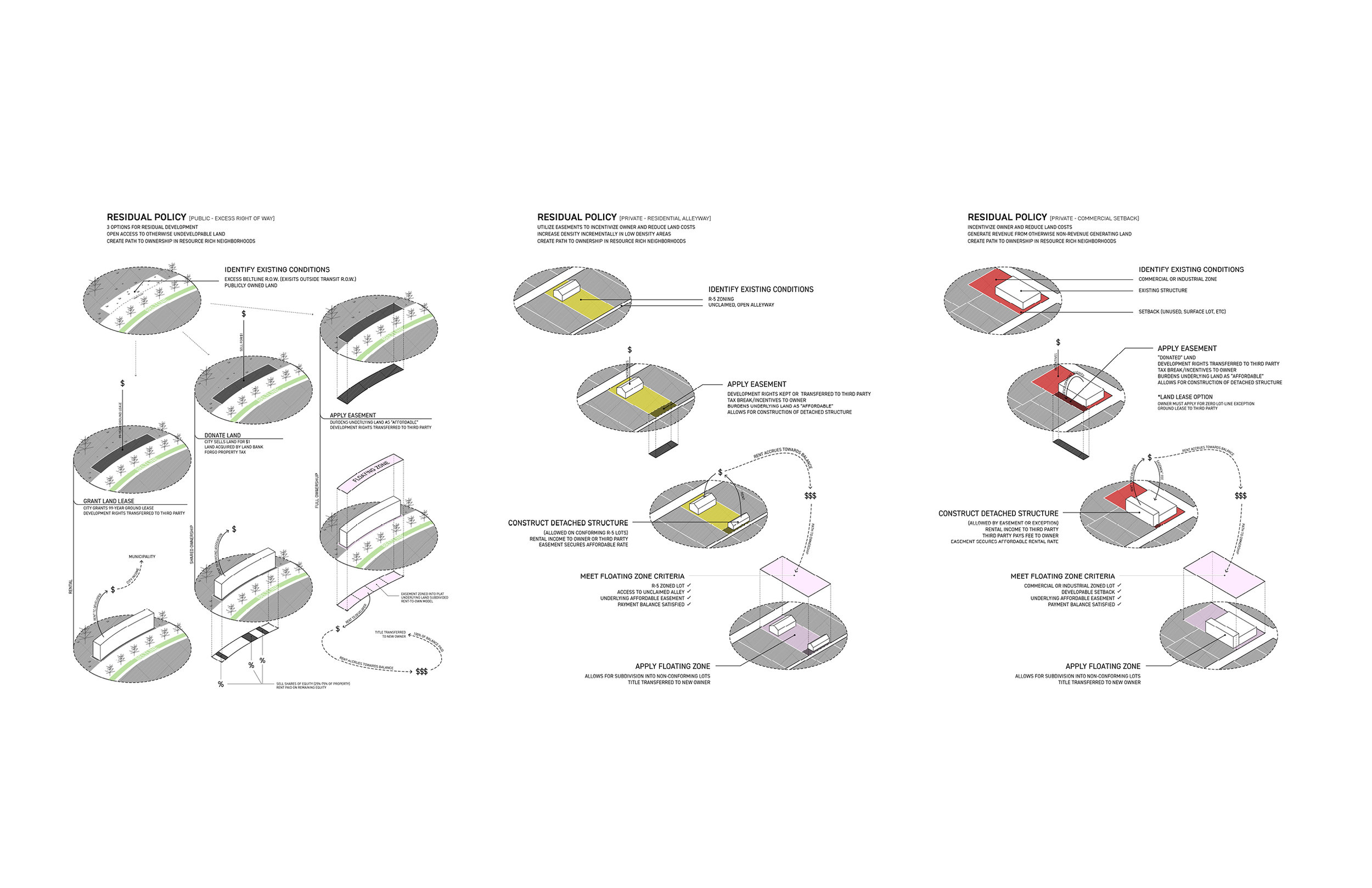
Each city has its own collection of “urban residue” - land leftover from standardized planning processes and regulations. Residual spaces, though underutilized or simply forgotten, have opportunity for granular urban development, and can be found in affluent and resource-rich neighborhoods. These spaces include, but may not be limited to: alleyways, shared lots, shared driveways, city-owned lots, parking lots, infrastructural buffers, environmental buffers, and roofspace. Atlanta has an abundance of wasted, residual space that not only can be leveraged to increase density efficiently and affordable, but can also build upon a natural morphology that preserves the character and urban qualities of their place. The development of Atlanta’s urban residue provides an alternative, scattered approach to generating density and urbanism in a city where large swaths of land is continuously being sold off to big developers.
This research utilizes an analysis of Atlanta’s urban fabric in search of residual spaces: leftover land that can be leveraged as sites for housing. A systematic approach has identified sites based on a number of criteria including proximity to public transit, schools, and sewer and water infrastructure. These sites would lend itself to different typological constraints and inherently be limited in its size and shape, allowing for efficient and architecturally explorative design for affordable housing. The research has yielded hundreds potential sites, developing an urban catalogue of site typologies and shape grammars of Atlanta’s urban fabric. The cataloguing shows the potential of architectural diversity through scattered urban development. Potential policy proposals have been explored, showing various paths to unlocking these untapped spaces for development. The goal is to create a book (a “Residue Guide”) to show how to identify, design, and develop residual spaces.
A site from the research was chosen for a test design. It is currently excess public land (owned by the Atlanta Beltline). The chosen site is adjacent to an existing townhome development and a communications easement. The communications easement contains an anchor for the support cables of a nearby communications tower. The design strategy was to create a structure that not only celebrates the ecology of the site, but also improves it. The building steps down, following topography. The structure is raised to allow for rainwater to infiltrate the ground through bioswales. Therefore it is as if the building is not there in regards to stormwater runoff, as water flows in the same manner as it did before the building. Not only that, constructed bioswales and a wetland allows for greater infiltration than the compacted soil allowed for before.